by Kristine Schmucker. HCHM Curator
We continue with our focus on Historic Preservation and the people who established the trails, built the buildings, laid the railroad tracks and were pioneers in health care.
The Black Beaver/Col. W.H. Emory Trail
When asked to name a trail in Harvey County, most people immediately think of the Chisholm Trail. However, even the Chisholm Trail followed an older trail through Harvey County, the Black Beaver/Col. Emory Trail. The story behind the trail is part of Kansas’ story at the very start of the Civil War. In 1861, out of necessity a trail was created by two men, Black Beaver and Col. William Emory through the heart of what would become Harvey County.
Trail Blazers
Black Beaver: “Guide & Interpreter”
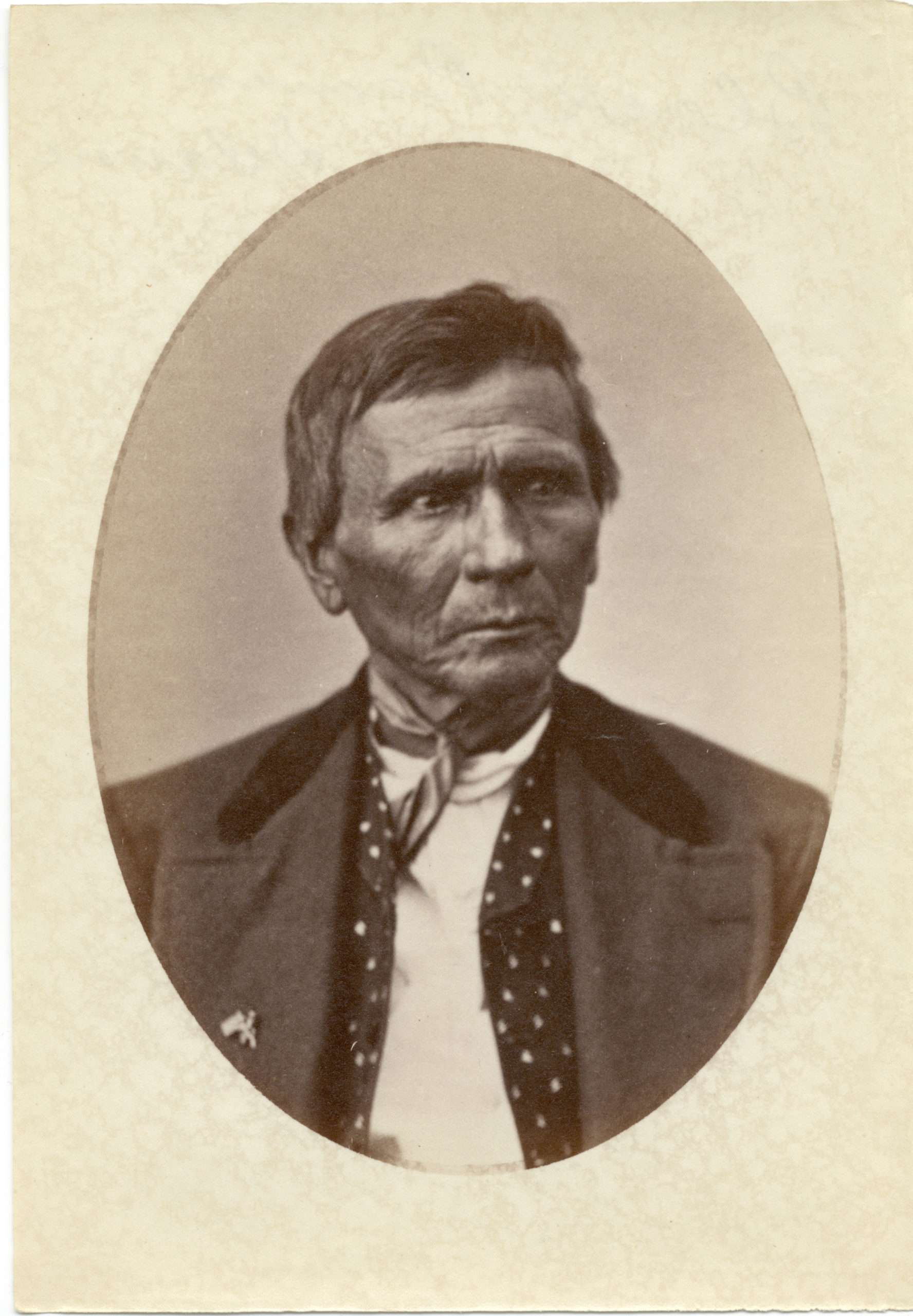
Black Beaver, born in Belleville, Ill, 1806.
Black Beaver, the son of a Delaware chief known as Capt Patterson, was an experienced guide in 1861. Described as an unassuming man with a “roving disposition,” Black Beaver was frequently used as an interpreter and guide. In 1840, Black Beaver served as a guide for an expedition organized by famed naturalist John Audubon. Throughout the 1830s, 40s and 50s, he worked for the American Fur Company as a scout and guide. He spoke eight Native American languages and was fluent in sign language in addition to English, French, and Spanish.
One expedition led by Black Beaver as guide and interpreter included his friend Jesse Chisholm. The two men were guides for Col. Henry Dodge to the main village of the Wichita on North Fork of the Red River in the summer of 1834. During the Mexican/American war, “Captain Black Beaver” led a group of Indian scouts and American expeditionary forces.
Black Beaver was well respected and known for his truthfulness and honest dealings with everyone he met from military officers to the “wild Indians of the plains.”
Col. William H. Emory “Map Maker”
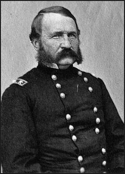
Called “Bold Emory” by his West Point 1831 graduating class, William H. Emory was born in Anne’s City, Maryland. Although he was involved in the military in many ways, Col. Emory was best known for his mapmaking skills. Early in his career, he surveyed harbors and the Delaware River. He was commissioned as a surveyor by the president to establish the Gadsden Purchase boundaries. By the start of the Civil War, due to his mapmaking skills with attention to detail and accuracy, Col. Emory was considered the authority of the trans-Mississippi west.
The Challenge – April 1861
In 1861, Col. William H. Emory was in a vulnerable position. Tensions were high between southerners or secessionists and the Union north. Stationed at Fort Washita in Indian Territory, Emory, a Federal officer, was surrounded by secessionist states. In April 1861, he was forced to evacuate his troops after receiving reports of the advance of Confederate troops from Arkansas and Texas. At Fort Cobb, Emory was able to move against a Confederate advance guard under the leadership of William W. Averell. Emory was successful in part due to an advance warning from a Delaware scout, trader and rancher, Black Beaver. With the information provided by Black Beaver, Emory was able to capture the first prisoners of the Civil War.
Following the battle, Col. Emory was responsible for “the largest concentration of federal troops in Indian Territory” which included:
“eleven companies, 750 fighting men, 150 women, children, teamsters and other non-combatants. . . about eighty wagons with about six hundred horses and mules.”
The challenge? To get to Fort Leavenworth, Kansas safely with his troops and the captured prisoners. He needed to navigate through miles of open, uncharted prairie and territory occupied by Confederates and Indians.
Emory needed a knowledgeable guide. He turned to his friend, Black Beaver.
The Trail: “Without Map or Chart”
At the opening of the Civil War, Black Beaver, now in his 50s, was focused on ranching. However, Col. Emory “appealed to Black Beaver as a guide in an effort to extricate . . . the garrisons.” Black Beaver was reluctant to leave his successful farm with “considerable stock” a few miles from Ft Cobb. He feared without his presence, the farm would “fall into the hands of the enemy and be lost to him.” Emory promised “the government would fully recompense him for any losses.” So, he agreed.
Years later Black Beaver would note that
“one of his most notable achievements was that of piloting the garrisons of abandoned federal military posts in the Indian Territory out of the country to Fort Leavenworth, Ks at the outbreak of the Civil War.”
They traveled over “300 miles, more than two thrids (sic) of which was a trackless wilderness, but Black Beaver was not at a loss. . . .Without map or chart, straight as the crow flies, he laid his course and men still travel the route.” to Ft Leavenworth, Kansas.
Upon arriving at Leavenworth, Col. Emory noted everyone was in “good condition, not a man, an animal, an arm, or wagon . . .lost except two deserters.”
Black Beaver’s trail goes directly through present day Newton and Harvey County.
Where did the Trail go?
Ancient Native American Trails have been discovered all over the city of Newton. One runs just west of Main from 1st street to 10th street where it joins another trail leading to a spot near Sand Creek where several trails come together. Other trails meet at a spot where the Ash Street Bridge is located today. Most of these trails remain unnamed or indicated on maps a “Indian Trail.”
The Black Beaver/Col. Emory Trail was a significant north/south route through Sedgwick, Harvey and Marion Counties and pre-dates the Chisholm Trail. In fact, Black Beaver would later suggest this route to his friend Jesse Chisholm.
The Route In Harvey County
The trail enters Harvey County on S. Anderson Rd. Brian Stucky discovered a unique trail pattern while researching. He identified seven pairs of wagon tracks sandwiched between two sets of Indian trails suggesting military wagons and equipment.
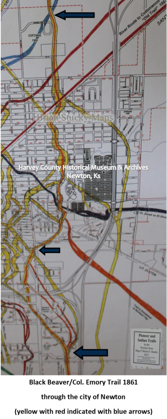
Detail of Black Beaver Trail through Newton, Ks. Courtesy Brian Stucky.
The main branch enters Newton south of the Newton Medical Center and crosses Walmart parking lot and interstate going north. There is a slight turn east near the Newton Country Club and continues north past St. Mary’s and Greenwood Cemetery and Chisholm Middle School, continues north along Duncan street over 12th street to Centennial Park.
The trail exits Harvey County at Spencer Rd and the Marion County line. This matches the historic documentation of the Black Beaver/Col Emory Trail.

Black Beaver/Col. Emory Trail through Harvey County
After the successful venture each man went on with their lives. Col. William Emory devoted 45 years to the military of the United States and died on December 1, 1887, in Washington, D.C.
Black Beaver returned to his ranch and discovered his fears had come true. “Turned His Face Toward Home” tells the rest of Black Beaver’s story.
A previous version of this post, “A Roving Disposition: Black Beaver” was published on December 20, 2019.
Sources
- Thank you to Brian Stucky for the Pioneer Trails in the Newton Area Maps, 2013 and the related written guide. The maps, created by Brian Stucky, of the trails in Harvey County are available to study at the HCHM Archives, Newton, Ks.
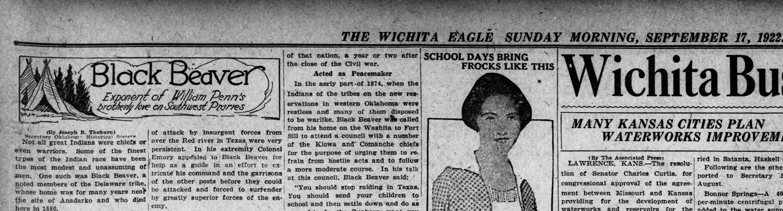
- Wichita Daily Eagle 17 September 1922. Written by Joseph B. Thoburn.
- Pioneer & Indian Trails Map, Brian Stucky, HCHM Archives
- Thoburn, Joseph Bradfield. A Standard History of Oklahoma: An Authentic Narrative of Its …, Volume 1. The American Historical Society, 1916. Accessed via google books, p. 278-279.
- Warde, Mary Jane. When the Wolf Came: The Civil War and the Indian Territory. University of Arkansas Press, 2013. Accessed via google books, p. 50-51.